Page 2 of 3
Re: Wind Behavior: 0400 - 0600
Posted: Fri Apr 03, 2020 5:23 pm
by marcelo_malara
Hi guys.
I used an excel I have done once with the geostrophic wind formula. Data:
-distance between London and the Orkneys 950 km
-isobar passing by the Orkneys 996 mb
-isobar passing by the Thames 1011 mb
-pressure diff 15 mb
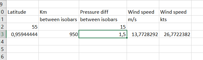
Result 26 kt. The geostrophic wind is the wind resulting from straight isobars, no centrifugal force involved. With the isobars as seen in the UK it would be a good aproximation. For the ones around the low, as on Iceland, the wind will be less, because on the curved isobars around a low, the centrifugal force away from the centre opposes the pressure gradient force towards the centre, so 15/20 kt seems plausible. May be it is a decaying low, I would need to see more variables to determine this, for example the 1000-500 thickness is the best for this.
Re: Wind Behavior: 0400 - 0600
Posted: Sat Apr 04, 2020 1:58 am
by Byron Angel
Great investigation, Marcelo. Thank you for sharing.
I did a bit of looking in my library as well and found some relevant remarks in an old USN publication "Climate and Weather for Flight in Naval Operational Zones"; Aviation Training Division, Office of the Chief of Naval Operations, U. S. Navy; 1944. According to this book, low pressure zones in the arctic reaches of the North Atlantic often produced powerful winds, but were also known to rather rapidly decay in strength. FWIW.
It is exciting to see what sort of results can be produced when we work together.
BRgds / Byron
Re: Wind Behavior: 0400 - 0600
Posted: Sat Apr 04, 2020 7:23 am
by hans zurbriggen
Hello,
to Mr.Malara writing: "15/20 kt seems plausible."
Thanks to Mr.malara for the calculation. However, looking at Beaufort wind scale (Wiki link:
https://en.wikipedia.org/wiki/Beaufort_scale), 15 -20 knots do not match at all what we see in the images (photos and film from PG). 'White Horses' are very rare in all images not supporting any wind more than 15 knots.
I still think no more than 10-12 knots during the battle (force 3 , max 4), looking at the available images.
hans
Re: Wind Behavior: 0400 - 0600
Posted: Sat Apr 04, 2020 3:58 pm
by marcelo_malara
Thanks for your words Byron.
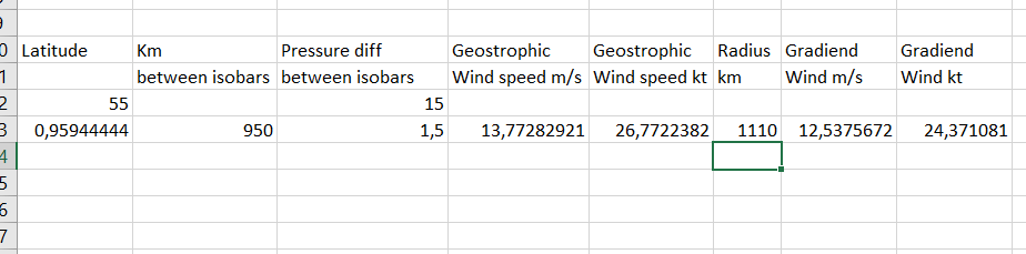
Hans, I mentioned 15/20 for some wind below the 26 surely found in the UK, may be it was 15, I don´t really know. There is a way to calculate it accurately, besides the pressure gradient (pressure diff / distance) the radius of the curved isobar needs to be used in a formula, let me do it.
Regards
Re: Wind Behavior: 0400 - 0600
Posted: Sat Apr 04, 2020 5:42 pm
by marcelo_malara
Added to the excel the corretion for gradient wind around a low. The gradient wind is the one that besides pressure gradient force and Coriolis effect, takes into account the centrifugal force provoked by the wind following a curved isobar. Using the same presure gradient as before, and measuring the radius from the center of the low to the isobar passing to the S of Iceland as 600 nm, 1110 km, the gradient wind would be just a little lower at 24 kt. Again, bear in mind the inaccuracies of the chart, the inaccuracies of the measurements in a conic projection, etc...
Re: Wind Behavior: 0400 - 0600
Posted: Sat Apr 04, 2020 9:34 pm
by Bill Jurens
My thanks to those who have provided meteorological charts for the 24 May action. Well done!
I might ask two things.
First -- as weather evolves even over short periods -- exactly what time of day is depicted on the charts already provided. Are these for 12:00 noon GMT or some other time?
Secondly, I'd be very interested in finding out the source(s) for these, as it might be useful to see similar charts for the 25th, 26th, and 27th, or -- if they are being used in further discussions -- have some method to tie them in to some known reference source. I had, I believe, once recovered meteo charts for 27 May, but am no longer sure I can find them.
Many thanks in advance...
Bill Jurens
Re: Wind Behavior: 0400 - 0600
Posted: Sat Apr 04, 2020 10:46 pm
by marcelo_malara
Re: Wind Behavior: 0400 - 0600
Posted: Sun Apr 05, 2020 2:47 am
by Bill Jurens
Thank you so much for the internet references. What wonderful resources these are!
Bill Jurens
Re: Wind Behavior: 0400 - 0600
Posted: Sun Apr 05, 2020 3:30 pm
by Byron Angel
One issue to be taken into consideration is that weather effects may in fact differ to a certain degree in localities separated by only a relatively few miles. For example, during the Age of Sail period, a line of battle of 35-40 ships maneuvering at two cables interval between ships might stretch for ten miles. There are recorded instances when wind strength/direction differed to some degree between van and rear.
In the case of Denmark Strait, we have the case of Prinz Eugen's KTB indicating a change of wind direction from NW to E at some moment prior to or at 0600 hrs. No mention of same seems to appear in British reports, so it is not possible to determine whether this wind shift occurred as well in the vicinity of Prince of Wales. A mystery ... although it might be worth looking into the logs of Suffolk and Norfolk.
FWIW.
B
Re: Wind Behavior: 0400 - 0600
Posted: Sun Apr 05, 2020 5:47 pm
by marcelo_malara
We cannot disregard "the human factor", may be at 6 am, just in the middle of the battle, the crew was a little busy and worried to assess correctly the wind direction.
Anyway, there are some explanations that I can put forward:
-changes in wind speed: they just happen at any moment, are very common, known as "gusts", occur when winds in layers a little higher than sea level (where wind speeds are higher due to lack of surface frition) come down and produce a sudden increase in wind speed
-presence of Cumulus nimbus (Cb) clouds: known as storm clouds, they are accompanied by thunder and lightning. A characteristic of the Cb is the presence of the so called "gust front", the Cb has a descending flow of air, the downdraft, that on touching the ground expends radially, provoking horizontal strong winds from different directions according of where you are respect to the downdraft
-cold front: a line that separates masses of air of different temperature, humidity and pressure. The wind blows from far different directions on both sides of the front, so an advancing front will generate a sudden change of direction in passing. For example, in the River Plate it is common to have N winds before front passage, backing to the S with the passage
Gust fronts and cold fronts are very similar at first sight, the difference is that the gust front is a temporary phenomena, lasting less than an hour, after that wind speed and direction goes to previous values, whereas on passing of a cold front the wind direction change and mainteins for a few days.
Re: Wind Behavior: 0400 - 0600
Posted: Tue Apr 07, 2020 8:53 am
by paul.mercer
Gentlemen,
Out of interest, would the wind have any significant effect on the flight of heavy shells?
Re: Wind Behavior: 0400 - 0600
Posted: Tue Apr 07, 2020 4:34 pm
by Bill Jurens
Basically, no. Wind affects the point of impact somewhat, but does not usually have any significant effect on terminal conditions. Relative ship speeds -- both the firing ship and the target are usually moving during the firing -- can make a fair difference, though. If both ships are steaming head-to-head at 30 knots (an unusual situation, to be sure...) one has an effective change in the horizontal component of the striking velocity of roughly 1.7 x 60 = approximately 100 ft/sec. These issues, as well as a related small change in the effective angle of fall as well, are virtually always neglected.
Bill Jurens
Re: Wind Behavior: 0400 - 0600
Posted: Tue Apr 07, 2020 4:47 pm
by marcelo_malara
Well, I had opened a new threat about this, but we can deal with it here. So Bill, if the wind have no great effect, why it was used in the firing computers? Why not disregard it completely?
Re: Wind Behavior: 0400 - 0600
Posted: Tue Apr 07, 2020 5:11 pm
by Bill Jurens
That's a good question, which requires differentiating fire control issues from ballistic phenomena. Because the effects of wind ARE important in determining -- or at least estimating -- the precise point of fall, as are (in some situations), earth rotation, etc., these effects are important in deciding exactly where to point the guns in order to strike the target. But although a 500 yard error in range is plenty enough to cause a salvo to miss completely, more-or-less completely negating the utility of fire in the first place, that same 500 yard error in range doesn't make much difference in terminal conditions. For a typical 'big gun' at around 20000 yards, an increase in range of 500 yards might decrease the striking velocity by about 15 ft/sec, and the angle of fall by about 2/3 of one degree. Those are pretty small numbers, especially when one compares them with the effects of relative ship motions. Irregardless, one has no direct control over these terminal effects anyway -- they are what they are, and one in effect "takes whatever one gets" in terminal conditions as a consequence of hitting the target in the first place. For those reasons, these changes in striking conditions are very rarely of any practical consequence. Basically one aims to hit the target, not to satisfy any predetermined set of terminal conditions once the target is hit.
Bill Jurens
Re: Wind Behavior: 0400 - 0600
Posted: Wed Apr 08, 2020 1:29 am
by marcelo_malara
Don´t quiet understand. Is there any estimation of how much can vary the point of impact using/disregarding wind data?
Regards