May 23/24 night shadowing and interception approach CS1/BC1

Discussions about the history of the ship, technical details, etc.

Moderator: Bill Jurens

User avatar
wadinga
Senior Member
Posts: 2472
Joined: Sat Mar 12, 2005 3:49 pm
Location: Tonbridge England

Re: May 23/24 night shadowing and interception approach CS1/BC1

Post by wadinga »

Hello All,

Rhys-Jones has a very similar map. Antonio, I believe that with no decent visibility


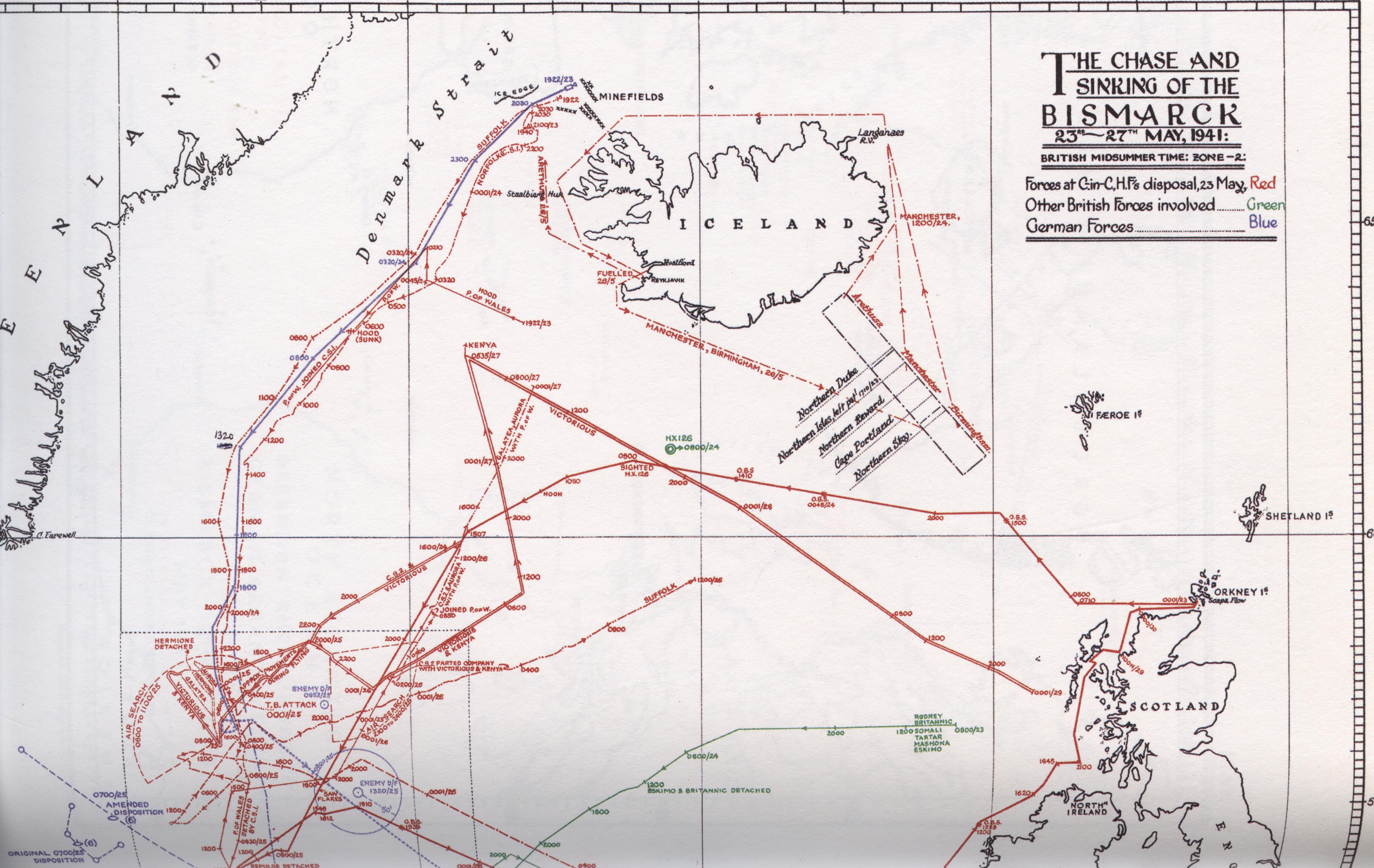
13. 0015 (B). Entered snowstorm; mean course 200°. Visibility until 0315 averaged one mile.
and a closing speed approaching 60 knots it was logical to turn onto a similar course to Bismarck at 02:03, but still stay between her and her apparent objective- the open Atlantic :shock: . It is unclear to me when PoW's M/F D/F bearings which were of limited accuracy, indicated Suffolk was not NNE but actually NNW, but as you deduct it was probably around 03:20 this was realised.. However as we have discussed before, such radio bearings do not indicate distance.

At 02:03 there was still the possibility that Lutjens had evaded the cruisers in the poor visibility and turned back. So the destroyers had to be sent to cover this. There were two strategic objectives: protect the convoys and get Bismarck. Holland had to cover both eventualities.

Always we must remember the interception difficulty, none of the British ships had any significant speed advantage over the German. Once an advantageous position was lost it could only be laboriously regained if at all. PoW was slower than either enemy vessel.

The battle location was always moving at nearly 30 knots. Like the Red Queen one had to run as fast as possible just to stay in the same place. https://en.wikipedia.org/wiki/Red_Queen%27s_race

Good luck Paul

All the best
wadinga
"There seems to be something wrong with our bloody ships today!"
User avatar
Antonio Bonomi
Senior Member
Posts: 3799
Joined: Mon Oct 18, 2004 10:44 am
Location: Vimercate ( Milano ) - Italy

Re: May 23/24 night shadowing and interception approach CS1/BC1

Post by Antonio Bonomi »

Hello everybody,

@ Wadinga,

you wrote :
It is unclear to me when PoW's M/F D/F bearings which were of limited accuracy, indicated Suffolk was not NNE but actually NNW, but as you deduct it was probably around 03:20 this was realised.
I cannot have of course the information about the exact time when on board Hood they realized this situation, but I do have the exact time when on board PoW they realized and plotted on their own battle map this evidence, ... it was at 02.29 for the Norfolk and at 02.39 for the Suffolk.

On PoW at that point everything was clear about it, ... I assume on board the Hood it occurred just a bit earlier ...

I agree with you about all your other above evaluations regarding difficulties, delta speed and poor visibility.

@ Paul Cadogan,

further to West, ... compared to where they were reporting themselves ... as I show you now on the map here below.

@ CAG,

thanks for the compliments and the nice offering of course more than welcome.
I will write you a message with my e-mail, as I have part of them but not all of them, so nice to complete the information there.
Holland_decision_inputs_05.jpg
Holland_decision_inputs_05.jpg (102.71 KiB) Viewed 787 times
By looking at the above positions comparison, ... between what has been reported and what was the reality one can realize easily that Suffolk and Norfolk radio trasmitted positions determined the 00.17 ( Norfolk close confirming Suffolk ) ViceAm Holland BC1 warshisp course to North ( Point C course change at 00.17 just after Norfolk message ), ... going for the enemy interception planned at around 02.00 am, ... that was missed due to the real situation that was a lot different than received/assumed.

In fact, at 00.28 Suffolk was around 25 sea miles to West with the enemy ahead of her, ... Norfolk was around 10 sea miles West of her own reported position at 00.17 but in reality around 30 sea miles ( 15 base +15 delta error to Suffolk position ) from the enemy and the Suffolk, ... and not close to them at all.

Bye Antonio :D
In order to honor a soldier, we have to tell the truth about what happened over there. The whole, hard, cold truth. And until we do that, we dishonor her and every soldier who died, who gave their life for their country. ( Courage Under Fire )
User avatar
Antonio Bonomi
Senior Member
Posts: 3799
Joined: Mon Oct 18, 2004 10:44 am
Location: Vimercate ( Milano ) - Italy

Re: May 23/24 night shadowing and interception approach CS1/BC1

Post by Antonio Bonomi »

Hello everybody,

@ All,

on the bottom of the first page on the top left corner you can read 2 radio messages :

http://www.sfu.ca/~dmunro/images/PI1_2_3.jpg

1) From HMS Suffolk at 01.31 with his geographical estimated position 65° 12' North 28° 33' West

2) From HMS Norfolk at 01.45 with his geographical estimated position, ... 64° 49' North 28° 16' West ... that based on the above and previously declared Suffolk position ( at 01.31 ) ... calculate ( by plotting ) and was communicating also his assumed distance from the enemy ( on bearing 269° from him ) being 18 sea miles.

It should be sufficiently clear now that both the above geographical positions were incorrect, and the Norfolk was NOT at 18 sea miles from the enemy as he estimated, ... but at 18+15= 33 sea miles from the enemy ... this because 15 more sea miles should be added due to the error correction difference between Suffolk ( +25 sea miles to West ) and Norfolk ( +10 sea miles to West ) ... being 25-10 = 15 sea miles to West being the correction adjustment distance between the Norfolk and the Suffolk.

That was the way, ... since the evening before, ... of HMS Norfolk to execute her " shadowing " effort, ... ONLY based on the HMS Suffolk communications as reference to establish the enemy presumed position.

If on board HMS Hood, they got with RD/F the bearings of the above 2 radio messages and plotted them just as they did on board the Norfolk, ... probably they realized that something was not correct at that point because Suffolk was to NNW of them, ... while Norfolk was NNE of them, ... while by plotting they declared positions they should have been both on NNE of them.

Probably, ... but this is just my personal opinion, ... after some more controls made by Commander Warrand, ... ViceAdm Holland decided to turn to a SSW course at 02.03, ... sailing parallel to the NNW position of Suffolk ( and enemy ahead of her ) between him and the Ice Edge, ... waiting for a more defined situation to be realized as soon as possible.

Bye Antonio :D
In order to honor a soldier, we have to tell the truth about what happened over there. The whole, hard, cold truth. And until we do that, we dishonor her and every soldier who died, who gave their life for their country. ( Courage Under Fire )
User avatar
wadinga
Senior Member
Posts: 2472
Joined: Sat Mar 12, 2005 3:49 pm
Location: Tonbridge England

Re: May 23/24 night shadowing and interception approach CS1/BC1

Post by wadinga »

Hello Antonio,

Thank you for this excellent representation. Your TOO 10:30 has come in whilst I was typing :D Can you say exactly what shift you have applied to correct Suffolk's position. It appears to be 270 whereas
The mean of these placed the enemy some 280°, 14 miles from Suffolk's plot position, and sights obtained shortly afterwards confirmed this.
As I have pointed out before this should be read that Bismarck's position moves about 14 miles west on 280 because it imples Suffolk's position should also move 280 not 270. . To be clear, I believe the track you have here for Bismarck is Suffolk's estimate relative to her own corrected position. I guess you hope to backtrack a closer approximation to reality by back navigating from Bismarck's gunnery on the killing salvo at 06:00 on Hood's wreck position though this range/bearing is still a little questionable.

The PoW MF/D/F for Norfolk at 02:29 still puts her to the east of the revised Hood/PoW track, and about 03:00? Norfolk turns to port away from Bismarck as the visibility is still very poor and Suffolk's incorrect position report at 02:56 means W-W considers he might run into Bismarck at point blank range. A previous scenario you have shown included Norfolk turning 90 degrees to port for 20 minutes before returing to base course. This map apparently shows a turn to only approximately south. Does the Norfolk log give any detail of these course changes?

Sometime after 03:20 Norfolk starts turning more to the west and crosses the BCF track, but since she was ENE of PoW at 02:29 and has been moving east relative to the BCF, with little if any speed advantage, she must cross the BCF track well astern. She has been on the outside line as the chase has turned to starboard. Norfolk is now effectively out of the chase.

Whilst running in the snow showers with no visibility and only Suffolk's incorrect radio positions to go on from before the loss of contact, Norfolk has been living on borrowed time for several hours. At 03:00 W-W knows nothing of the BCF's "proximity" and there is nothing to be gained by throwing away his ship in a potential encounter at point blank range when Suffolk apparently has a lock on the enemy. Better to open the assumed range a little, and as Suffolk's report of radically improved visibility at 03:15 implies, when Norfolk swings to the west at 03:20 it is because she can potentially see her enemies. Except that both they and the BCF are many miles ahead.

It is unclear whether it would have been RN SOP to get M/F D/F bearings (albeit with inherent limitations) for all friendly transmissions.

Your TOO 10:30 is most illuminating.

All the best

wadinga
"There seems to be something wrong with our bloody ships today!"
User avatar
Antonio Bonomi
Senior Member
Posts: 3799
Joined: Mon Oct 18, 2004 10:44 am
Location: Vimercate ( Milano ) - Italy

Re: May 23/24 night shadowing and interception approach CS1/BC1

Post by Antonio Bonomi »

Hello everybody,

@ Wadinga,

Suffolk between 260°-270°; Norfolk between 230°-240°.

At 03.00 Norfolk was at around 40 sea miles from Suffolk ( for them at 25 sea miles, plus the 15 sea miles delta error between them ) ... than due to the 02.56 Suffolk radar contact with the enemy ( 10 sea miles South of Suffolk communicated position on that moment ), ... Norfolk felt herself " uncomfortably close " to the enemy and enlarged the distance considerably, ... she went to some like 50 sea miles ( those are real, for them were 35 sea miles on that moment) from the Suffolk at 03.20 after a " prudential runaway " to South East at 30 knots, ... adding 10 sea miles distance in 20 minutes.

At 03.00 she back crossed to West of BC1, ... to go back to East of BC1 due to her fast runaway, ... and came back being 16 sea miles from BC1 at 03.20, crossing to West of BC1 back track once again at 03.50.

At 05.35 and 05.41 she was where my geometrical figure you know very well positioned her, ... after having had BC1 on her port bow at 05.16 at 16 sea miles ... no doubts.

Adm Lutjens " Z " move at 05.21-05.32 put Norfolk in condition to close to BC1 after her interception report.

Bye Antonio :D
In order to honor a soldier, we have to tell the truth about what happened over there. The whole, hard, cold truth. And until we do that, we dishonor her and every soldier who died, who gave their life for their country. ( Courage Under Fire )
User avatar
wadinga
Senior Member
Posts: 2472
Joined: Sat Mar 12, 2005 3:49 pm
Location: Tonbridge England

Re: May 23/24 night shadowing and interception approach CS1/BC1

Post by wadinga »

Hello Antonio,

There is something I don't follow here.
You say
03.20 after a " prudential runaway " to South East at 30 knots, ... adding 10 sea miles distance in 20 minutes.
in response to my question:
A previous scenario you have shown included Norfolk turning 90 degrees to port for 20 minutes before returing to base course. This map apparently shows a turn to only approximately south. Does the Norfolk log give any detail of these course changes?


Where do you get a turn to SE from? Please answer this specific point. If you now admit he was 33 miles behind Bismarck at about 01:45 and then
she went to some like 50 sea miles ( those are real, for them were 35 sea miles on that moment)
by 03:20 from Suffolk. how can he possibly be 11miles away from Bismarck (Diagram B) by 06:00? How far does Norfolk have to catch up Bismarck from her distance at 03:20?

You have just surely disproved part of your own thesis. :cool:

Please let's have the "reasonable" Antonio of your TOO 10:30 back.

All the best

wadinga
"There seems to be something wrong with our bloody ships today!"
User avatar
Antonio Bonomi
Senior Member
Posts: 3799
Joined: Mon Oct 18, 2004 10:44 am
Location: Vimercate ( Milano ) - Italy

Re: May 23/24 night shadowing and interception approach CS1/BC1

Post by Antonio Bonomi »

Hello everybody,

@ Wadinga,

I was giving you the distances between Norfolk and Suffolk, ... :wink: ... not with the enemy that was in different positions compared to the Suffolk position on the various course changes.

At 01.45 the Norfolk was closer to the Germans and more South of them ... than to the Suffolk, .. but he did not know that ... :wink:

The above map from the Admiralty is just very generic, ... the warships did a lot of course alterations ... including the Germans ... and at the end Norfolk was where I put her on my geometrical bearings figure at 05.35.

Of course I cannot give you now all the details, ... otherwise nobody will buy my future Bismarck books ... :wink:

Bye Antonio :D
In order to honor a soldier, we have to tell the truth about what happened over there. The whole, hard, cold truth. And until we do that, we dishonor her and every soldier who died, who gave their life for their country. ( Courage Under Fire )
User avatar
wadinga
Senior Member
Posts: 2472
Joined: Sat Mar 12, 2005 3:49 pm
Location: Tonbridge England

Re: May 23/24 night shadowing and interception approach CS1/BC1

Post by wadinga »

Hello Antonio,

So is that no actual evidence of a 90 degree turn to port at all then? Not on a chart, not in a logbook?

Your post said:
was communicating also his assumed distance from the enemy ( on bearing 269° from him ) being 18 sea miles.

It should be sufficiently clear now that both the above geographical positions were incorrect, and the Norfolk was NOT at 18 sea miles from the enemy as he estimated, ... but at 18+15= 33 sea miles from the enemy ...
My underlining.

Still controversy sells books, I'm sure they will sell like hot cakes. Did I tell you about the Jack Broome libel case against David Irving over The Destruction of PQ 17. That was really controversial. The £40,000 settlement against Irving and the publishers was the biggest at the time and the print run was pulped. They had to reissue with changes. :D

All the best

wadinga
"There seems to be something wrong with our bloody ships today!"
dunmunro
Senior Member
Posts: 4394
Joined: Sat Oct 22, 2005 1:25 am
Location: Langley BC Canada

Re: May 23/24 night shadowing and interception approach CS1/BC1

Post by dunmunro »

Here's a high res scan of the Battle Summary 5 chart:

http://www.sfu.ca/~dmunro/images/DSchart2.jpg
User avatar
Antonio Bonomi
Senior Member
Posts: 3799
Joined: Mon Oct 18, 2004 10:44 am
Location: Vimercate ( Milano ) - Italy

Re: May 23/24 night shadowing and interception approach CS1/BC1

Post by Antonio Bonomi »

Hello everybody,

@ Wadinga,

do not confuse the 01.45 situation with the 03.00, ... as the relative positioning was a lot changed.

YES, there is a real evidence of that 90° Norfolk turn away to port at 03.00 and it is more evident and clear than the showed small curve on the Battle Summary Nr. 5 map Duncan is attaching here.

It is showed on the Norfolk own track map.

Bye Antonio :D
In order to honor a soldier, we have to tell the truth about what happened over there. The whole, hard, cold truth. And until we do that, we dishonor her and every soldier who died, who gave their life for their country. ( Courage Under Fire )
User avatar
Alberto Virtuani
Senior Member
Posts: 3605
Joined: Mon Jul 08, 2013 8:22 am
Location: Milan (Italy)

Re: May 23/24 night shadowing and interception approach CS1/BC1

Post by Alberto Virtuani »

@Dunmunro:
Hi Duncan, thanks for posting this very high resolution version of Battle Summary n.5. I only had a bad one up to now. :clap:


@all:
looking at the map above, at the messages from the 2 British cruisers and at Antonio's reconstructed distances, I wonder how the official version of the story can say that both Norfolk and Suffolk were "shadowing" Bismarck.

AFAIK (not being a native English speaker....), "shadowing" implies having the enemy under visual or radar contact (even if not continuously, but at least picking it up frequently to ensure its position and course are known). According to all the above, ONLY Suffolk was shadowing, at distances varying from 15sm to 10 sm, taking all the risks and keeping under strict surveillance the German squadron, with the exception of the loss of contact for around 2 hours in the night.

Norfolk never "shadowed" Germans, that night. AFAIK, she never picked up enemy (neither visually nor via radar) from the evening encounter till 5:41, she just "covered" a possible ( :?: ) turn to South-East of Lutjens (see W-W report), keeping herself at minimum 15 sm from enemy (and due to the wrong communicated positions, being at 30+ sm from it), just re-transmitting Suffolk messages and her own position..... I know Norfolk radar was not performing as Suffolk one, but this just means that she should have taken more risks (picking enemy up at less than 8-10 sm) to actually "shadow" the enemy, mission for which she had been sent out at sea anyway......


I do think we need to distinguish between the 2 cruisers when speaking about their role that night, recognizing Suffolk shadowing role, despite all difficulties and errors.


Bye, Alberto
"It takes three years to build a ship; it takes three centuries to build a tradition" (Adm.A.B.Cunningham)

"There's always a danger running in the enemy at close range" (Adm.W.F.Wake-Walker)
dunmunro
Senior Member
Posts: 4394
Joined: Sat Oct 22, 2005 1:25 am
Location: Langley BC Canada

Re: May 23/24 night shadowing and interception approach CS1/BC1

Post by dunmunro »

Alberto Virtuani wrote:@Dunmunro:
Hi Duncan, thanks for posting this very high resolution version of Battle Summary n.5. I only had a bad one up to now. :clap:


@all:
looking at the map above, at the messages from the 2 British cruisers and at Antonio's reconstructed distances, I wonder how the official version of the story can say that both Norfolk and Suffolk were "shadowing" Bismarck.

AFAIK (not being a native English speaker....), "shadowing" implies having the enemy under visual or radar contact (even if not continuously, but at least picking it up frequently to ensure its position and course are known). According to all the above, ONLY Suffolk was shadowing, at distances varying from 15sm to 10 sm, taking all the risks and keeping under strict surveillance the German squadron, with the exception of the loss of contact for around 2 hours in the night.

Norfolk never "shadowed" Germans, that night. AFAIK, she never picked up enemy (neither visually nor via radar) from the evening encounter till 5:41, she just "covered" a possible ( :?: ) turn to South-East of Lutjens (see W-W report), keeping herself at minimum 15 sm from enemy (and due to the wrong communicated positions, being at 30+ sm from it), just re-transmitting Suffolk messages and her own position..... I know Norfolk radar was not performing as Suffolk one, but this just means that she should have taken more risks (picking enemy up at less than 8-10 sm) to actually "shadow" the enemy, mission for which she had been sent out at sea anyway......


I do think we need to distinguish between the 2 cruisers when speaking about their role that night, recognizing Suffolk shadowing role, despite all difficulties and errors.


Bye, Alberto
At 0229 Norfolk sighted a large vessel @ 8nm bearing 298d. At 0255 Norfolk sighted another vessel at a similar range and bearing which she thought might be Suffolk.
User avatar
Alberto Virtuani
Senior Member
Posts: 3605
Joined: Mon Jul 08, 2013 8:22 am
Location: Milan (Italy)

Re: May 23/24 night shadowing and interception approach CS1/BC1

Post by Alberto Virtuani »

Hi Duncan,
exactly as I said: Norfolk never picked up enemy (identifying it) again. She did not therefore "shadow" during the night.

The "sightings" (not confirmed by W-W) you reported were most probably .... BC1.... :oops:


Bye, Alberto
"It takes three years to build a ship; it takes three centuries to build a tradition" (Adm.A.B.Cunningham)

"There's always a danger running in the enemy at close range" (Adm.W.F.Wake-Walker)
dunmunro
Senior Member
Posts: 4394
Joined: Sat Oct 22, 2005 1:25 am
Location: Langley BC Canada

Re: May 23/24 night shadowing and interception approach CS1/BC1

Post by dunmunro »

Alberto Virtuani wrote:Hi Duncan,
exactly as I said: Norfolk never picked up enemy (identifying it) again. She did not therefore "shadow" during the night.

The "sightings" (not confirmed by W-W) you reported were most probably .... BC1.... :oops:


Bye, Alberto
It's not possible to definitively identify the vessel sighted by Norfolk at 0229 and 0255 bearing 298d. The D/F bearing to Norfolk reported by PoW prove that Norfolk did not sight BC1. Even if it was Suffolk, that would put Norfolk at about the same distance to Bismarck as Suffolk was and it means that your statement:
keeping herself at minimum 15 sm from enemy (and due to the wrong communicated positions, being at 30+ sm from it), just re-transmitting Suffolk messages and her own position.....
and Antonio's:
Antonio Bonomi wrote:Hello everybody,

@ Wadinga,

Suffolk between 260°-270°; Norfolk between 230°-240°.

At 03.00 Norfolk was at around 40 sea miles from Suffolk ( for them at 25 sea miles, plus the 15 sea miles delta error between them ) ... than due to the 02.56 Suffolk radar contact with the enemy ( 10 sea miles South of Suffolk communicated position on that moment ), ... Norfolk felt herself " uncomfortably close " to the enemy and enlarged the distance considerably, ... she went to some like 50 sea miles ( those are real, for them were 35 sea miles on that moment) from the Suffolk at 03.20 after a " prudential runaway " to South East at 30 knots, ... adding 10 sea miles distance in 20 minutes.
is incorrect.

Norfolk took incredible (and unjustifiable) risks in making and reporting these two contacts. Both Bismarck and PE had radar and together they could have ambushed and destroyed Norfolk unless W-W exercised extreme caution.
User avatar
Antonio Bonomi
Senior Member
Posts: 3799
Joined: Mon Oct 18, 2004 10:44 am
Location: Vimercate ( Milano ) - Italy

Re: May 23/24 night shadowing and interception approach CS1/BC1

Post by Antonio Bonomi »

Hello everybody,

@ Dunmunro,

there are no doubts that at 02.29 and 02.55 the Norfolk saw the BC1 warships, ... most likely the back of HMS Prince of Wales.

What he reported ... we can discuss about it .... since on board the HMS Norfolk they were a lot confused on sending reports on that moment ... as you can easily realize yourself by looking the reality and compare it with the Norfolk message content ... :shock:

Here the messages :
Norfolk_Suffolk_msg_0229_0256.jpg
Norfolk_Suffolk_msg_0229_0256.jpg (97.8 KiB) Viewed 629 times
Here the map :
Holland_decision_inputs_06.jpg
Holland_decision_inputs_06.jpg (45.41 KiB) Viewed 629 times
Between 02.29 and 02.55 the Norfolk was very close to the BC1 warships, ...and still very far away from the HMS Suffolk, ... especially at 02.55 when the real distance between the 2 heavy cruisers county class was around 40 sea miles.

Just plot and then ... after the " correction " factors ... measure yourself ... :wink:

Bye Antonio :D
In order to honor a soldier, we have to tell the truth about what happened over there. The whole, hard, cold truth. And until we do that, we dishonor her and every soldier who died, who gave their life for their country. ( Courage Under Fire )
Post Reply