From Leach report it is probable that the decision to turn away was taken BEFORE any hits were received on the PRince of Wales.Byron Angel wrote:
Santarini's comment that turn [c] was initially also part of an effort to clear Hood makes it difficult to determine the precise moment when Leach actually decided to break off the action.
Denmark Strait and RN Articles of War
Moderator: Bill Jurens
-
alecsandros
- Senior Member
- Posts: 4349
- Joined: Wed Oct 14, 2009 2:33 pm
- Location: Bucharest, Romania
Re: Denmark Strait and RN Articles of War
-
Antonio Bonomi

- Senior Member
- Posts: 3799
- Joined: Mon Oct 18, 2004 10:44 am
- Location: Vimercate ( Milano ) - Italy
Re: Denmark Strait and RN Articles of War
Hello everybody,
@ Wadinga,
Sean, the Hood versus Bismarck distance at 06.00 is a known parameter with some tolerances : 15.000 to 16.000 meters ( 16.300 to 17.250 yards ), around 8 to 8.5 sea miles.
My map of 2005 shows it at 16.000 meters.
Norfolk track once we know speed and course changes is a given fixed parameter as well.
It is enough to place it in there at 276 from PG ( 05.35 ) and 230 from Hood ( 06.00 ).
The 18 from PoW at 05.35 will come out in any case as a consequence no matter what, simply because it is correct.
You can always do a double check, ... print my latest map detail version, ... cut the Norfolk track with a scissor and move it around to find the place that according to you fits the best.
In my opinion there is only one place were it is consistent with current known parameters, exactly were I placed it.
Bye Antonio
In order to honor a soldier, we have to tell the truth about what happened over there. The whole, hard, cold truth. And until we do that, we dishonor her and every soldier who died, who gave their life for their country. ( Courage Under Fire )
-
Dave Saxton

- Supporter
- Posts: 3148
- Joined: Sat Nov 27, 2004 9:02 pm
- Location: Rocky Mountains USA
Re: Denmark Strait and RN Articles of War
Byron Angel wrote:..... At the risk of further complicating affairs, Santarini's new book on Hood/Bismarck (which I have only just received) offers an interesting view re PoW's maneuvering at the crucial moment of the battle.
The author argues that PoW made three turns:
[a] an initial turn to port conforming to Hood's turn to bring her starboard A arc to bear.
a hard turn to starboard to clear PoW's bow of Hood's wreck after she had been stricken.
[c] then a hard turn to port to swing PoW's stern away from Hood's wreck, which was continued into a full turn away.
Santarini's comment that turn [c] was initially also part of an effort to clear Hood makes it difficult to determine the precise moment when Leach actually decided to break off the action.
Interesting book so far.
B
This makes sense. The penant for the 20* turn was hoisted by Holland at 0555 according to Grenfell, so Hood and Prince of Wales should have mostly completed or completed the course change by or before 0600. This may require of POW a more rapid starboard correction to avoid Hood's wreckage. But also remember POW was not following directly behind Hood, but off the starboard quarter, so maybe not too a severe correction was required. From Jasper's perspective a relatively slight turn by POW to starboard would appear to be more straight toward the PG because of the relative courses the two opponants were on, which were not very parallel.
Entering a night sea battle is an awesome business.The enveloping darkness, hiding the enemy's.. seems a living thing, malignant and oppressive.Swishing water at the bow and stern mark an inexorable advance toward an unknown destiny.

Re: Denmark Strait and RN Articles of War
For Steve Crandell,
Steve,
Antonio's latest map is 8:57 on Sunday 9th March and the map with GREEN and VIOLET scenarios on Sunday February 9th.
For Antonio,
All the best
wadinga
Steve,
Antonio's latest map is 8:57 on Sunday 9th March and the map with GREEN and VIOLET scenarios on Sunday February 9th.
For Antonio,
This is surely exactly the same as VIOLET. Except the bit about 018T. Only GREEN uses 018T to generate an origin for Norfolk's track and delivers an invented bearing of 215 to Hood at 06:00, instead of using what Norfolk logged. You have stated several times that VIOLET is wrong, but not why. Once again it complies with the logged bearings unlike GREEN. It says Norfolk was 28,000 yds from Bismarck at 06:00.It is enough to place it in there at 276 from PG ( 05.35 ) and 230 from Hood ( 06.00 ).
The 18 from PoW at 05.35 will come out in any case as a consequence no matter what, simply because it is correct.
All the best
wadinga
"There seems to be something wrong with our bloody ships today!"
-
Alberto Virtuani

- Senior Member
- Posts: 3605
- Joined: Mon Jul 08, 2013 8:22 am
- Location: Milan (Italy)
Re: Denmark Strait and RN Articles of War
Hi Sean, the last map posted by Antonio on Sunday at 8:57 PM (see above in this thread) uses 230 bearing to Hood at 06:00 and it's IMHO more accurate than the Violet and the Green ones.Wadinga wrote: "Only GREEN uses 018T to generate an origin for Norfolk's track and delivers an invented bearing of 215 to Hood at 06:00,"
The track is in "Violet" but distances are close to the "Green" ones (the only that match with evidences from both sides and with the Triangle of Doom.....). 018T is a consequence (and a confirmation that it was quite a precise bearing).
Bye, AlbertoTherefore, as Antonio Bonomi wrote, "Wake-Walker was at 11 sea miles from the enemy at 06.00"
"It takes three years to build a ship; it takes three centuries to build a tradition" (Adm.A.B.Cunningham)
"There's always a danger running in the enemy at close range" (Adm.W.F.Wake-Walker)
"There's always a danger running in the enemy at close range" (Adm.W.F.Wake-Walker)
-
Steve Crandell
- Senior Member
- Posts: 954
- Joined: Wed Feb 05, 2014 7:05 pm
Re: Denmark Strait and RN Articles of War
It appears to me that Norfolk was either trying to close with Bismarck or PoW, depending on the courses. She was really unable to do so because there was not much of a difference in speed and the Germans were mostly going away.
-
alecsandros
- Senior Member
- Posts: 4349
- Joined: Wed Oct 14, 2009 2:33 pm
- Location: Bucharest, Romania
Re: Denmark Strait and RN Articles of War
Exactly ! It appears she was trying desperately to close the range, but when Hood exploded, they just went back to normal course. They probably felt their efforts in vain...Steve Crandell wrote:It appears to me that Norfolk was either trying to close with Bismarck or PoW, depending on the courses. She was really unable to do so because there was not much of a difference in speed and the Germans were mostly going away.
Re: Denmark Strait and RN Articles of War
Hello Alberto,
I'm utterly astonished to hear that you agree with Antonio that his new map is better than the previous two scenarios. Who'd have thought it!
You say He also says VIOLET is wrong although never explaining why. Surely you both now agree GREEN is wrong as well.
I have tried all the stuff about scissors but I cannot get the two maps to print out at the same scale so such a comparison is impossible and of course there is no scale or compass rose on the new map so as to be sure the length and orientation of Norfolk's track is the same. It's certainly strange how the new map track starts where the GREEN track started on the original map (018T from PoW) yet ends up in a place where the bearing to Hood is the same as VIOLET. Surprisingly Norfolk also ends up being the same desirable distance from Bismarck 11 miles whether it bears 215(as in green) or 230 to Hood, as on the new map. It's also unfortunate that scaled lengths are in such tiny font that the scanning has rendered them virtually illegible.
All the best
wadinga
I'm utterly astonished to hear that you agree with Antonio that his new map is better than the previous two scenarios. Who'd have thought it!
You say
because it agrees withit's IMHO more accurate than the Violet and the Green ones.
Since Antonio has not yet explained why or how the new track is better or even why it is different to the other two, maybe you can explain why?(the only that match with evidences from both sides and with the Triangle of Doom.....)
I have tried all the stuff about scissors but I cannot get the two maps to print out at the same scale so such a comparison is impossible and of course there is no scale or compass rose on the new map so as to be sure the length and orientation of Norfolk's track is the same. It's certainly strange how the new map track starts where the GREEN track started on the original map (018T from PoW) yet ends up in a place where the bearing to Hood is the same as VIOLET. Surprisingly Norfolk also ends up being the same desirable distance from Bismarck 11 miles whether it bears 215(as in green) or 230 to Hood, as on the new map. It's also unfortunate that scaled lengths are in such tiny font that the scanning has rendered them virtually illegible.
All the best
wadinga
"There seems to be something wrong with our bloody ships today!"
-
Antonio Bonomi
- Senior Member
- Posts: 3799
- Joined: Mon Oct 18, 2004 10:44 am
- Location: Vimercate ( Milano ) - Italy
Re: Denmark Strait and RN Articles of War
Hello everybody,
@ Wadinga,
Sean, Alberto is right because he knows that I have used more parameters than before ( GREEN / VIOLET ) in order to make my last VIOLET new track above.
That made the difference and more or less we can state that the NEW VIOLET track is something in between the previous two ( More GREEN than VIOLET ).
Here they are in official and original form for you to realize in detail.
At 05.41 : Bismarck at 280 degrees and Prinz Eugen at 276 degrees ( confirmed by Prinz Eugen with 96 degrees bearing from the other side ) at 16 sea miles ( incorrect, it was 14,5 sea miles ).
At 05.50 : From Norfolk bridge Hood and Prince of Wales were bearing 220 degrees at 14 sea miles.
At 06.00 : From Norfolk bridge Hood was bearing 230 degrees at 15 sea miles ( incorrect, she was at 10-11 sea miles from Hood )
After you position the HMS Norfolk track using the above parameters you realize that :
1) Norfolk at 05.35 was at 18 degrees bearing from Prince of Wales ( or PoW was bearing 198 degrees from Norfolk if you like it better this way ).
2 ) ADM 116/4351 Diagram B is correct in principle, both for distance versus Hood as well as versus Bismarck, ... I can accept it was incorrect for bearings and azimuth, but you have to realize they did not have on 1941 the Bismarck/Prinz Eugen precises track references I have.
Bye Antonio
@ Wadinga,
Sean, Alberto is right because he knows that I have used more parameters than before ( GREEN / VIOLET ) in order to make my last VIOLET new track above.
That made the difference and more or less we can state that the NEW VIOLET track is something in between the previous two ( More GREEN than VIOLET ).
Here they are in official and original form for you to realize in detail.
At 05.41 : Bismarck at 280 degrees and Prinz Eugen at 276 degrees ( confirmed by Prinz Eugen with 96 degrees bearing from the other side ) at 16 sea miles ( incorrect, it was 14,5 sea miles ).
At 05.50 : From Norfolk bridge Hood and Prince of Wales were bearing 220 degrees at 14 sea miles.
At 06.00 : From Norfolk bridge Hood was bearing 230 degrees at 15 sea miles ( incorrect, she was at 10-11 sea miles from Hood )
After you position the HMS Norfolk track using the above parameters you realize that :
1) Norfolk at 05.35 was at 18 degrees bearing from Prince of Wales ( or PoW was bearing 198 degrees from Norfolk if you like it better this way ).
2 ) ADM 116/4351 Diagram B is correct in principle, both for distance versus Hood as well as versus Bismarck, ... I can accept it was incorrect for bearings and azimuth, but you have to realize they did not have on 1941 the Bismarck/Prinz Eugen precises track references I have.
- Norfolk_parameters_01.jpg (59.16 KiB) Viewed 826 times
In order to honor a soldier, we have to tell the truth about what happened over there. The whole, hard, cold truth. And until we do that, we dishonor her and every soldier who died, who gave their life for their country. ( Courage Under Fire )
-
Antonio Bonomi
- Senior Member
- Posts: 3799
- Joined: Mon Oct 18, 2004 10:44 am
- Location: Vimercate ( Milano ) - Italy
Re: Denmark Strait and RN Articles of War
Hello everybody,
You can add on the above map this detail now substituting the Norfolk previous track :
Here the track detail and distances :
Bye Antonio
http://hmshood.com/history/denmarkstrai ... trait2.htmSteve Crandell wrote:Will someone please post a link to the latest reconstruction map?
You can add on the above map this detail now substituting the Norfolk previous track :
- Violet_track.jpg (45.02 KiB) Viewed 825 times
Here the track detail and distances :
- Norfolk_details_01.jpg (40.8 KiB) Viewed 825 times
In order to honor a soldier, we have to tell the truth about what happened over there. The whole, hard, cold truth. And until we do that, we dishonor her and every soldier who died, who gave their life for their country. ( Courage Under Fire )
Re: Denmark Strait and RN Articles of War
Antonio doesn't it strike you a bit odd that Norfolk's two bearings on Holland are both rounded to 10 deg (220d + 230d) increments? To me this indicates that these are only approximations.Antonio Bonomi wrote:
At 05.50 : From Norfolk bridge Hood and Prince of Wales were bearing 220 degrees at 14 sea miles.
At 06.00 : From Norfolk bridge Hood was bearing 230 degrees at 15 sea miles ( incorrect, she was at 10-11 sea miles from Hood )
Bye Antonio
-
Antonio Bonomi
- Senior Member
- Posts: 3799
- Joined: Mon Oct 18, 2004 10:44 am
- Location: Vimercate ( Milano ) - Italy
Re: Denmark Strait and RN Articles of War
Hello everybody,
If you think that only some years ago on the majority of this battle maps the 2 British heavy cruisers were often never even drew on the map itself, surely we have done a huge step forward, ... first on 2005 putting them on the map the best I could do, ... and lately reaching a fair good approx as we are currently doing.
The HMS Norfolk was in there, ... 1 sea mile up or down, left or right will not make any change on the overall evaluations we are doing, ... as far as today precision I can reach that is the best I can do, ... and sincerely I cannot see were I could find better information to improve it now.
The only bitter taste I have is the Norfolk gunnery map full compliance, ... the average 13,5 sea miles is there at a certain point, ... the timing recorded was completely wrong ( 06.06 plus 16 minutes = 06.22 ) ... and there is nothing I can do about it to fit it better.
Anyway, I think that with your all positive and constructive challenges we have been able to do some history writing at a very good level here.
Bye Antonio
YES Duncan, I think I would agree with you about that, ... same goes also for the distances approx. to a sea mile, ... 13, 14 or 16 etc etc ... but as you can see on my attached details above this is what we have to play with.dunmunro wrote:Antonio doesn't it strike you a bit odd that Norfolk's two bearings on Holland are both rounded to 10 deg (220d + 230d) increments? To me this indicates that these are only approximations.Antonio Bonomi wrote:
At 05.50 : From Norfolk bridge Hood and Prince of Wales were bearing 220 degrees at 14 sea miles.
At 06.00 : From Norfolk bridge Hood was bearing 230 degrees at 15 sea miles ( incorrect, she was at 10-11 sea miles from Hood )
Bye Antonio
If you think that only some years ago on the majority of this battle maps the 2 British heavy cruisers were often never even drew on the map itself, surely we have done a huge step forward, ... first on 2005 putting them on the map the best I could do, ... and lately reaching a fair good approx as we are currently doing.
The HMS Norfolk was in there, ... 1 sea mile up or down, left or right will not make any change on the overall evaluations we are doing, ... as far as today precision I can reach that is the best I can do, ... and sincerely I cannot see were I could find better information to improve it now.
The only bitter taste I have is the Norfolk gunnery map full compliance, ... the average 13,5 sea miles is there at a certain point, ... the timing recorded was completely wrong ( 06.06 plus 16 minutes = 06.22 ) ... and there is nothing I can do about it to fit it better.
Anyway, I think that with your all positive and constructive challenges we have been able to do some history writing at a very good level here.
Bye Antonio
In order to honor a soldier, we have to tell the truth about what happened over there. The whole, hard, cold truth. And until we do that, we dishonor her and every soldier who died, who gave their life for their country. ( Courage Under Fire )
-
alecsandros
- Senior Member
- Posts: 4349
- Joined: Wed Oct 14, 2009 2:33 pm
- Location: Bucharest, Romania
Re: Denmark Strait and RN Articles of War
@Marc, Antonio, Alberto, allHerr Nilsson wrote:Antonio, it means that the distances were between 208 and 180 hm. Not closer.
Re-reading the Baron's account today I think I figured out what Lutjens meant by his message "running battle between 208 and 180hm"
And he is correct , to.
208hm = distance from the Hood at 5:55 (Bismarck OPENS FIRE)
180hm = distance from the Prince of Wales at 6:09 (Bismarck STOPS FIRE)
Hence "running battle between 208 to 180hm"
-
Herr Nilsson

- Senior Member
- Posts: 1585
- Joined: Thu Oct 21, 2004 11:19 am
- Location: Germany
Re: Denmark Strait and RN Articles of War
No. The distances of opening and ceasing fire would be useless for Group West. Group West states in its own war diary at 0942:
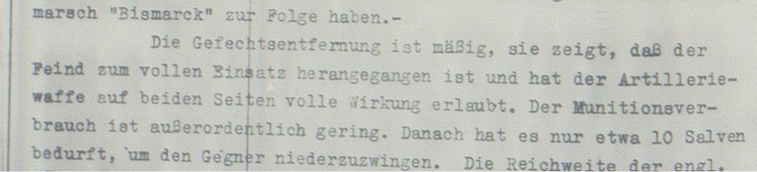

The battle distance is moderate, ...
Regards
Marc
"Thank God we blow up and sink more easily." (unknown officer from HMS Norfolk)
Marc
"Thank God we blow up and sink more easily." (unknown officer from HMS Norfolk)
-
alecsandros
- Senior Member
- Posts: 4349
- Joined: Wed Oct 14, 2009 2:33 pm
- Location: Bucharest, Romania
Re: Denmark Strait and RN Articles of War
"Useless to group west". Why ? It's a very short description of a running battle. [and by the way, the entire message, sent at 7:00 was useless - in confused them alot, saying radar contact could not be broken , allthough they knew it was !]Herr Nilsson wrote:No. The distances of opening and ceasing fire would be useless for Group West. Group West states in its own war diary at 0942:
The battle distance is moderate, ...
Do you have an alternative explanation ?